What is the Central El Camino Real Multimodal Plan (Central El Camino Plan)?
Originally designed as a state highway for high-speed auto travel, El Camino Real (El Camino) now faces challenges in providing a safe and efficient trip for the many people using it for multiple modes of travel every day. As the main roadway that connects San Mateo County, El Camino needs essential improvements to better connect people to key downtowns, businesses, schools, transit stations, and other destinations.
Get Involved
From now through February 28, review and provide feedback on design options for improving El Camino Real! Your input will help inform next steps in working with Caltrans to make improvements to El Camino Real.
Complete the survey ¡Complete la encuesta 完成问卷调查!
Upcoming Events
Pop-ups
San Mateo
San Mateo Library
55 W 3rd Avenue
Saturday, February 7, 2026; 1:00 PM - 4:00 PM
Virtual Community Workshop
Thursday, February 26, 2026; 6:00 PM - 8:00 PM
Can’t make it in-person? Join the virtual community workshop via Zoom on Thursday, February 26, from 6-8 PM. Click here to register.
Previous Pop-up Events
San Mateo
San Mateo Library
55 W 3rd Avenue
Monday, January 12, 2026; 1:00 PM - 4:00 PM
Belmont
Twin Pines Senior and
Community Center
20 Twin Pines Lane
Thursday, January 15, 2026; 10:30 AM - 12:30 PM
San Carlos
San Carlos Library (2nd floor)
610 Elm Street
Tuesday, January 20, 2026; 3:00 PM - 6:00 PM
About the Project
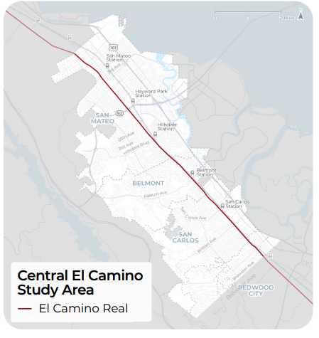
Led by SamTrans and the cities of San Mateo, Belmont, San Carlos, and Redwood City, the Central El Camino Real Multimodal Plan is a planning project that will improve transportation and safety along an eight and a half-mile stretch of El Camino.
Fact sheet Hoja informativa 情况介绍 информационный бюллетень
This project is funded by SamTrans and a Transit Performance Initiative (TPI) grant awarded by the Metropolitan Transportation Commission (MTC).
Contact
For questions, please contact grandboulevard@samtrans.com or 1-800-660-4287.

